Online maps consist of the following services:
- Static Maps
- Map Tiles
All services use the Web Mercator projection and produce PNG raster images. All coordinates are in WGS84.
Static Maps
Static maps are map images of arbitrary size, location and zoom level. All are programmable.
API
GET http(s)://api.marineplan.com/api/maps/<version>/<language>/<units>/<style>/<variant>/map.<ext>?<parameters>
Parameters
| parameter | description | values | default value |
|---|---|---|---|
| version | API version | 1 | – |
| style | map style |
|
– |
| variant | map style variant (only for basic style) |
|
– |
| ext | file format |
|
– |
| [point] | map center as WGS84 latitude,longitude | latitude= -90..90 longitude=-180..180 | 52.202242, 4.538984 |
| [zoom] | zoom level | 7..20 | 13 |
| [width] | width in pixels | 1..20000 | 512 |
| [height] | height in pixels | 1..20000 | 512 |
| language | map label language |
|
– |
| units | bridge and lock dimensions units |
|
– |
| key | API secret key, to be requested from MarinePlan | UUID | – |
Output
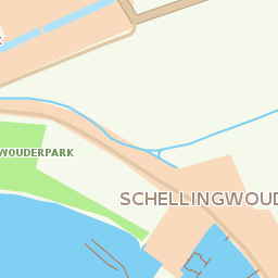
Example output for http(s)://api.marineplan.com/api/maps/1/nl/metric/basic/day/map.png?point=53.030288,5.663314
Example output for http(s)://api.marineplan.com/api/maps/1/nl/metric/basic/day/map.svg?point=53.030288,5.663314

Map Tiles
Map tiles are 256×256 PNG images as standardized by several industries. MarinePlan recommends the use of the Leaflet JS library to create an interactive map as depicted in the Interactive Map Demo.
API
GET http(s)://api.marineplan.com/tiles/<version>/<language>/<units>/<style>/<variant>/<zoom>/<x>/<y>.png?<parameters>
Parameters
| parameter | description | values | default value |
|---|---|---|---|
| version | map version | 2 | – |
| language | map label language |
|
– |
| style | map style |
|
– |
| variant | map style variant |
|
– |
| x | X tile number (numbers from Greenwich = 0) | 0..2zoom-1 | – |
| y | Y tile number (numbers from the equator = 0) | 0..2zoom-1 | – |
| zoom | zoom level | 6..20 | – |
| units | bridge and lock dimensions units |
|
– |
| key | API secret key, to be requested from MarinePlan | UUID | – |
Output
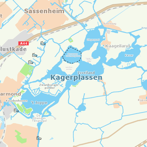
Example output for /tiles/2/nl/metric/basic/day/15/16835/10766.png